

Climate change increases precipitation and changes water management in the Netherlands. One of the challenges involved is the development of nature areas. To create nature, it is sometimes necessary to wetten regions. When some parts of the landscape are flooded, the changing water pressure can have unwanted effects on other parts of the landscape. Soil plays a crucial role in water management. Boulder clay, for example, is impermeable and has an influence on water management.

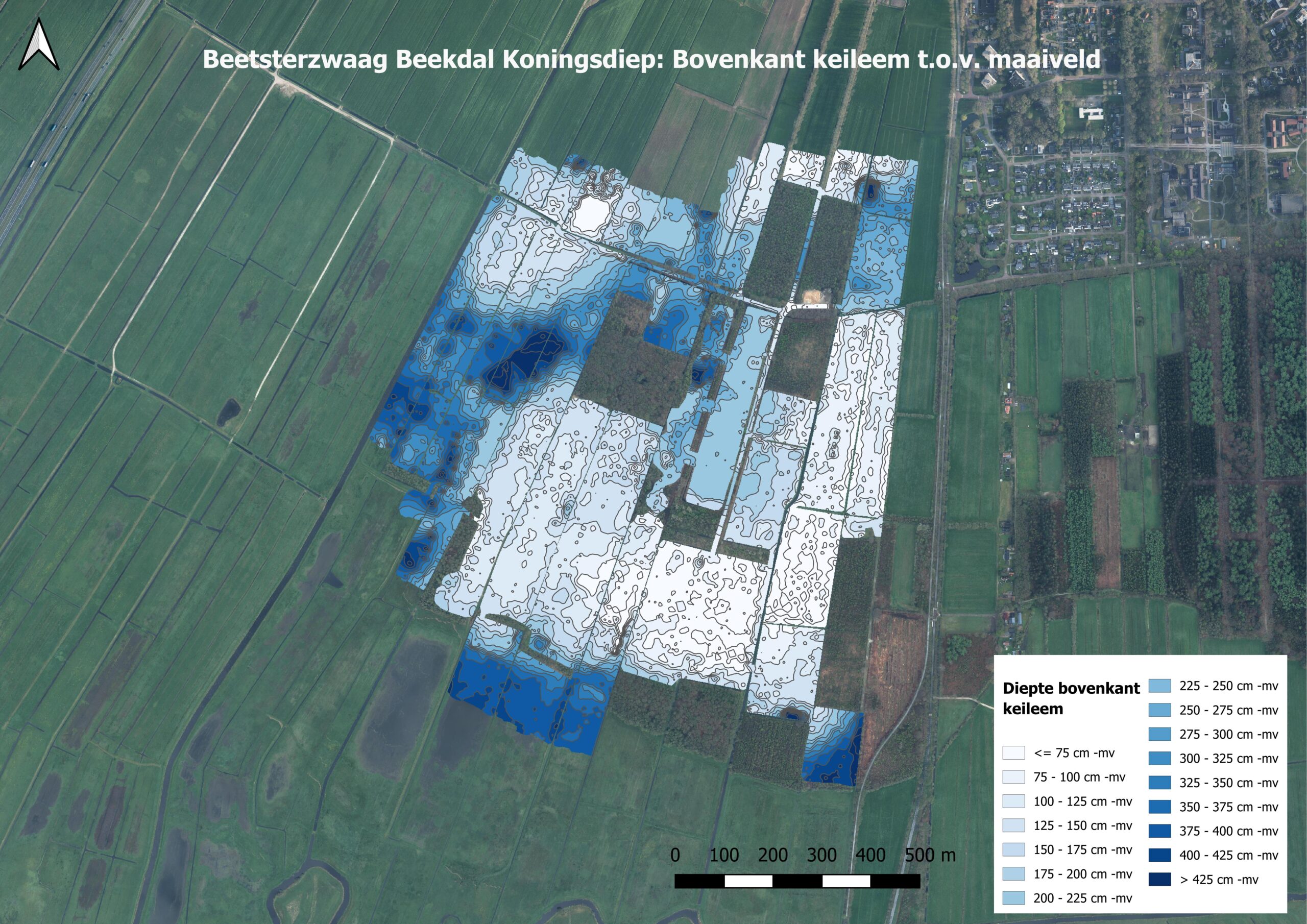
The area-wide map of boulder clay depth shows the spatial variation well.
A detailed, area-wide map of the underlying boulder clay is needed to gain a proper understanding of local hydrological conditions. Drilling is relatively labour-intensive only provides information on some points. An example of the importance of area-covering soil information for water management is a project in Beetsterzwaag. The Province of Fryslân is developing plans for redevelopment of a nature reserve southwest of Beetsterzwaag. Due to the underlying boulder clay, there are significant elevation differences with various sand and peat soils. In the lower parts where the boulder clay is thinner or missing, mineral-rich water can rise. These conditions create a wide variety of flora and fauna and give the area special natural values.
Generally, the location of the boulder clay layer broadly is known from drillings and other geological information. Locally and at a detailed level, however, the location of the boulder clay is not known. However, precise local and detailed knowledge of its exact position is often lacking. Therefore, Medusa measured the area comprehensively with ground-penetrating radar, using crosswise lines at 20-meter intervals. The obtained soil information revealed that the area, thought to be one large boulder clay plateau based on drilling, consists of two smaller plateaus with a valley in between.
A second example is the Ootmaanlanden near the Holtingerveld. Prolander, the implementing agency for rural area design in Drenthe and Groningen, is developing nature projects. Commissioned by the Province of Drenthe, Prolander is currently working on several nature development projects in South-West Drenthe to anticipate the change in water management to create climate buffers. To fully understand the hydrological effects of the water storage area, it is first necessary to gain a detailed picture of the shallow subsoil of the area, so excess water can be captured.

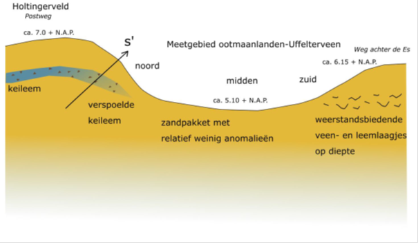
This conceptual soil cross-section of the soil structure in Ootmaanlanden, is based on ground radar measurements.
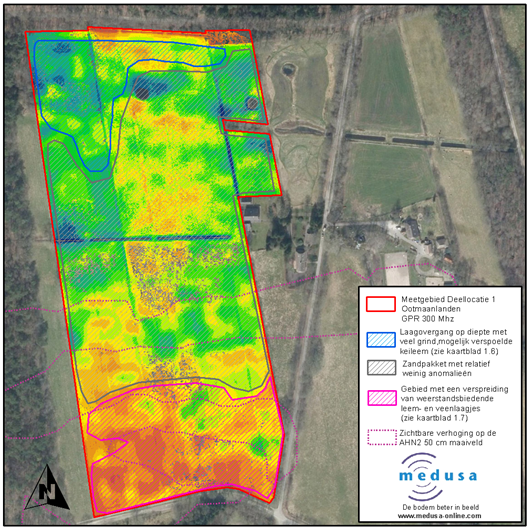
Medusa mapped the Ootmaanlanden in detail using a ground penetrating radar in a 10-meter cross grid. This data was processed into comprehensive maps with information about soil structure. This soil information is used for hydrological models that analyse waterflow in detail. It was found that a boulder clay layer is present in the northern part of the area. Local elevation differences probably caused erosion of the loam fraction from the base of the boulder clay layer and deposit it further away. This results in three distinct soil layers: an eroded boulder clay layer, a sand layer without anomalies, and a sand layer with resistant clay layers in the south.
A precise understanding of the subsurface is essential for predicting future changes in water management, especially given the changing precipitation patterns due to climate change. Medusa plays a crucial role by providing comprehensive soil information, which contributes to effective climate adaptation plans for water management.

Map of subsurface structure in the Ootmaanlanden. Used for the hydrological build-up of the nature reserve. Imaged with geophysics.